History of the Parkway
- 1889: Construction begins along the ancient gravel shoreline of glacial Lake Namadji, an ancestor of Lake Superior. A road there is first envisioned by William Rogers, the city's first park board president.
- 1892: Rimmed with rustic logs and protected along its sharp curves by granite boulders, Rogers Boulevard opens between what today are Chester Bowl and Lincoln Park. Construction costs of $312,000 are covered largely by a bond sale.
- 1899: Nearly two decades before he becomes Duluth's longest-serving mayor, Samuel F. Snively starts construction of what today is Seven Bridges Road. He envisions a narrow, winding roadway along Amity Creek that links with Rogers Boulevard and also provides him easier access to his home. He also hopes the construction provides much-needed jobs.
- 1901: Seven Bridges Road is completed for $12,000, about half of which comes from Snively himself. He later donates the road to the city.
- 1904: Boulevard construction begins west of Rogers Boulevard from Lincoln Park to Thompson Hill. The hill already is a well-known resting stop for horses after climbing Duluth's steep hillside.
- 1925: "The Mayor's Boulevard Extension," as it is called in city budgets, opens between Thompson Hill and Becks Road, offering views of Duluth's westernmost neighborhoods. Today, during winter months, much of this stretch is closed.
- 1928: The Mission Creek section to Fond du Lac opens, extending the boulevard to Jay Cooke State Park. But the new stretch was then widely ignored. Today, this section is a path in the woods closed to traffic.
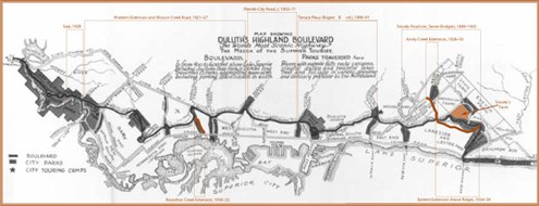
- 1929: Seven separate sections of the 28-mile boulevard are consolidated and officially dedicated as Skyline Parkway. The name is chosen from 4,000 entries in a contest sponsored by the Duluth News Tribune. Eager for the name to stick ("Rogers Boulevard" was never really embraced; most residents referred to the road simply as "The Boulevard"), the city places green-and-white road signs along the entire parkway.
- 1939: Hawk Ridge opens under Snively's watchful eye.
- 1995: Duluth's Heritage Preservation Commission hires Pat Nunnally, then with the St. Paul firm Loucks and Associates, to survey and study Skyline Parkway and its history as efforts begin to plan for its protection and preservation.
- 1996: City invests $112,500 to repair granite caps and do other work to restore a historic stone bridge along Seven Bridges Road. Other bridges later receive similar repairs.
- 1999: A nonprofit community group called the Western Skyline Planning and Preservation Alliance organizes to protect and preserve the aesthetic, environmental and historic character of Skyline Parkway.
- 2001: Skyline Parkway is designated a State Scenic Byway as city officials begin work on a corridor management plan. The plan is to map the future of the parkway, giving Duluthians the chance to help determine policies for managing the vegetation, the views and the historic character of the road. Duluth officials hire Minneapolis-based consultants URS/BRW Inc. to write the plan.
- 2003: The city completes the Skyline Parkway Corridor Management Plan for the entire length of the Parkway.
- 2010: Mayor Don Ness announces his intent to restore Skyline, a bit at a time, as part of a sustained effort, to begin in 2011. Work under the city's street-improvement program is expected to include mill and overlay.
SOURCES: Duluth News Tribune archives; research historian Pat Nunnally; 1994 article, "Snively's Road," by Mark Ryan, for Minnesota History magazine.
Contact
Duluth Parks & Recreation
Duluth City Hall
411 W 1st Street
Duluth, MN 55802
218-730-4300