Duluth Natural Areas Program
![]()
Program Overview:
The Duluth Natural Areas Program is designated by city ordinance (Chapter 2, Article XXIX) to designate certain lands with environmental value as permanently protected natural places. Duluth citizens have long recognized the value of these places to provide both natural resource protection and human sanctuary. Designating these lands ensures everyone in Duluth will always have access to these special places where they can appreciate nature and enjoy the outdoors. In doing so, Duluth preserves its natural heritage for the public good by:
- Ensuring the city can better manage Duluth’s forests, streams, and wetlands
- Supporting diversification of our region’s economy
- Promoting the well-being and happiness of our citizens and visitors
- Maximizing resiliency for a changing climate through the services these lands provide (e.g., controlling stormwater runoff, supporting diverse plant communities)
The City is committed to preserving in perpetuity public lands as determined in accordance with the criteria and to offer the opportunity for voluntary preservation of similar lands owned by others. These criteria include plant and animal communities, habitat for special species, natural water features, important bird habitat areas, and geologic landforms.
Additional Information about the City's Natural Areas Program:
The documents linked below have been archived and will not be updated. All links open in a new window.
- City Ordinance Establishing Duluth Natural Areas Program, 2002 (Archived)
- Duluth Natural Areas Program Brochure (Archived)
- Duluth Natural Areas Program Guidelines, Council Approved 09/9/2002 (Archived)
- Imagine Duluth 2035 Comprehensive Plan Update - Open Space Policies and Strategies
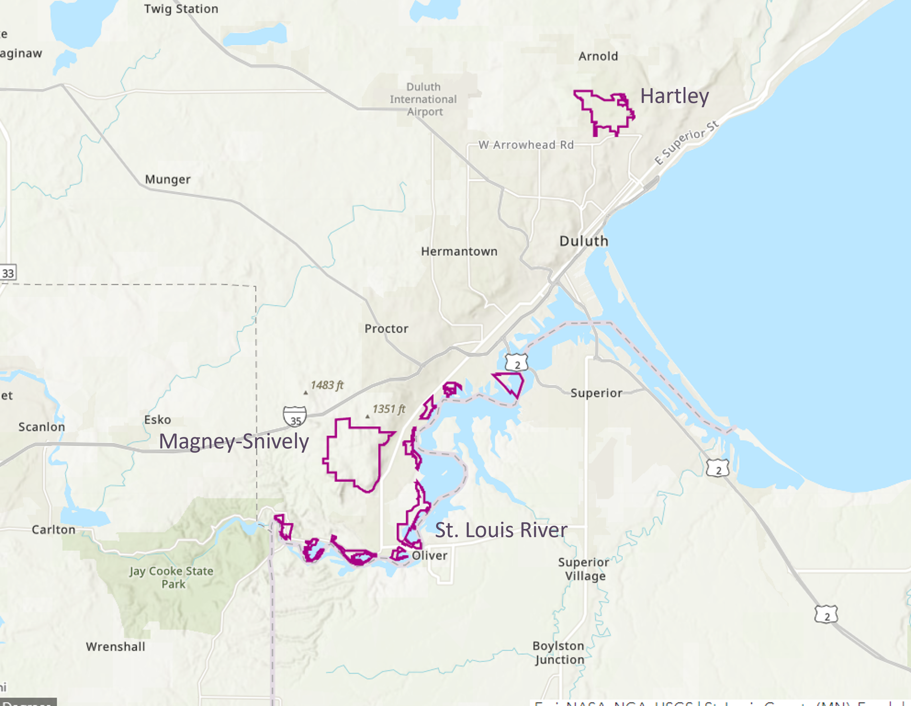
Hartley Natural Area
The Hartley Natural Area includes one of the largest northern hardwood forests and wet meadows in the City. The park also has a long history of education and recreational activity related to the enjoyment, preservation, and restoration of the natural environment. One of the City's beloved trout streams, Tischer Creek, also runs through Hartley and has a small watershed plan that was developed by the MN DNR and the City in 2024. This plan includes a list of projects to help restore and protect Tischer Creek, including several in Hartley. The City works closely with, and is extremely grateful for, the dedicated staff from Hartley Nature Center, who help us care for this designated natural area.
Hartley Documents:
The documents linked below have been archived and will not be updated. All links open in a new window.
St. Louis River Natural Area
The St. Louis River Natural Area is made up of nine separate parcels along the St. Louis River. A critically important bird flyway, this corridor of coastal wetlands and forests holds great significance to our community, our tribal partners, and the Great Lakes ecosystem. Many of the St. Louis River DNAP sites have been restored as part of a decades-long effort to delist the St. Louis River as an Area of Concern, including Grassy Point, Chambers Grove, and Radio Tower Bay. Our partners at the MN DNR are currently developing specific plans for the restored Area of Concern project sites to help the City and its partners successfully steward the St. Louis River designated natural area into the future.
St. Louis River Documents:
The documents linked below have been archived and will not be updated. All links open in a new window.
Magney-Snively Natural Area
Magney-Snively was designated as the first Duluth Natural Area in 2002. It has such ecological value that it was considered for designation as a Scientific and Natural Area by the MN DNR. Today this is a well-loved recreational and ecological treasure with two designated trout streams (Sargeant and Stewart) and several miles of Superior Hiking Trail running through it.
Magney-Snively consists of approximately 1,800 acres of 11 high quality native plant communities, one of which is the largest known Sugar Maple-Basswood forest in the area.
The City is currently updating the Management Plan for the Magney-Snively Designated Natural Area. The original plan was developed in 2002 and was quite brief, overly broad and custodial in nature. The updated plan will mimic the more modern plans for Hartley and the St. Louis River natural areas and will include prioritized protection and restoration projects with cost estimates and targeted completion dates. An Advisory Committee, made up of local natural resource professionals and representatives from the various recreational groups that use the area, is assisting the City with the plan update. Once complete, the City and partners can use the updated plan to help us seek funding for forest management, trail maintenance and water quality implementation projects. The timeline for this process is shown below.
2024:
- Advisory Committee Assembled
- Streams, Native Plant Communities, and Birds Studies
2025:
- Plan Development
- Advisory Committee Meetings
2026:
- Prioritized List of Implementation Projects Developed
- Final Plan Presented to Natural Resources Commission: June 3, 2026, 6pm, Conference Room 330 City Hall (opportunity for public comment)
- Final Plan Presented to Planning Commission: August 11, 2026, 5pm, Council Chambers City Hall (opportunity for public comment)
- Council Approval of Final Updated Plan: Expected August 2026 (opportunity for public comment)
- Implementation of One of the Prioritized Projects Listed in the Updated Plan
Magney-Snively DNAP Documents:
The documents linked below have been archived and will not be updated. All links open in a new window.
- Magney-Snively Report (Archived)
- Magney-Snively Management Plan (Archived)
- Magney-Snively DNAP Fact Sheet (Archived)
Lester-Amity-Hawk Ridge (LAHR) Designated Natural Area
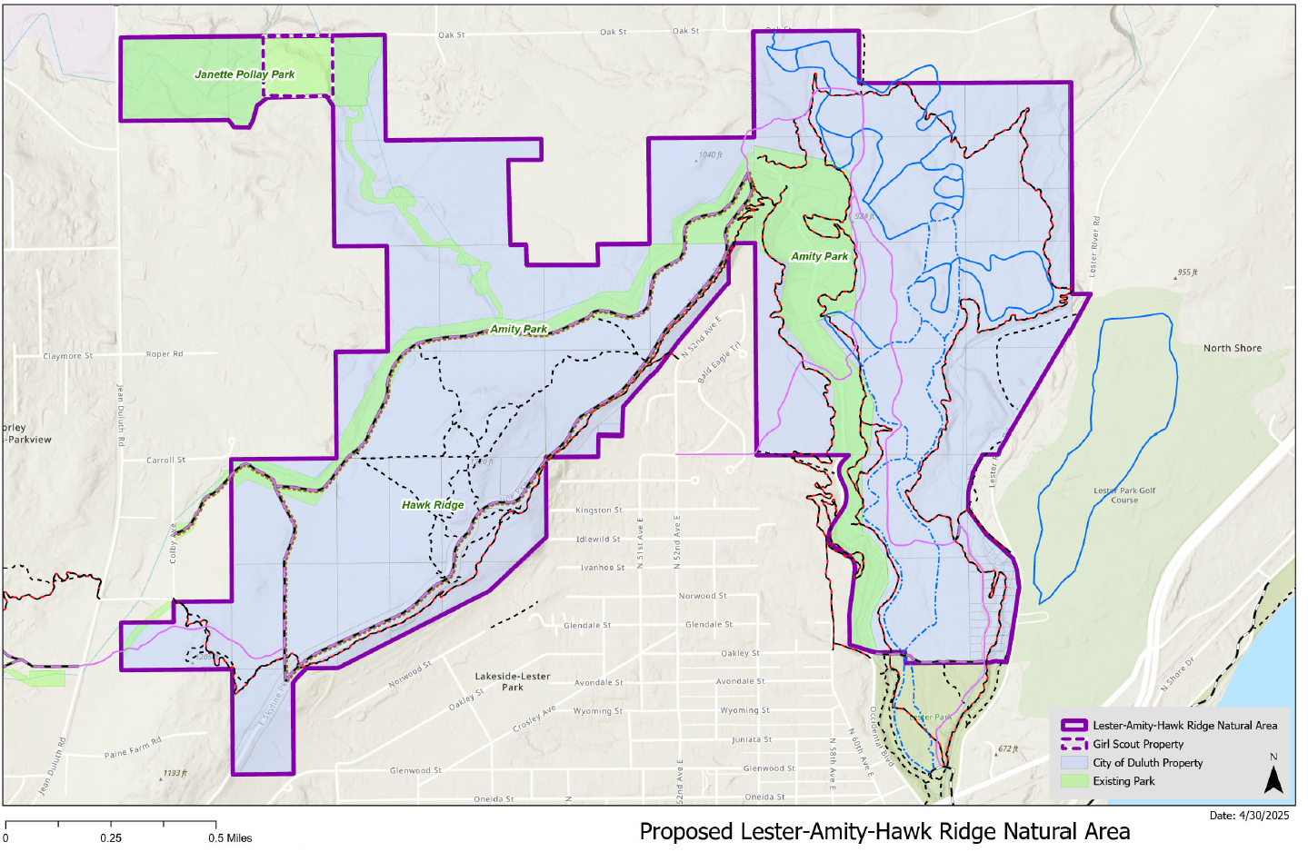
The Lester-Amity-Hawk Ridge (LAHR) designated natural area was the first brought forth by partners, instead of by the City itself. The MN Land Trust, Hawk Ridge Bird Observatory, South St. Louis Soil and Water Conservation District, and MN Trout Unlimited all have vested interests in this natural area and have been working separately to preserve bird habitat, Amity Creek, and the Lester Amity forests for many years. Under this new designation as a Natural Area, these partners are committed to actively protecting and restoring this natural area, which, with limited funding and staff, is greatly appreciated by the City. The LAHR Management Plan was approved by the Natural Resources Commission on June 3, 2026; by the Planning Commission on June 9, 2026; and finally by the City Council on June 29, 2026.
There were several presentations and opportunities for public comment during the Natural Area Designation process including:
- April 15, 2026, Stakeholder Meeting
- May 6, 2026, Natural Resources Commission Meeting
- June 9, 2026, Planning Commission Meeting
- June 29, 2026, City Council Meeting
Lester-Amity-Hawk Ridge DNAP Documents: